Soviet Union Information Bureau
THE Union of Soviet Socialist Republics occupies the largest territory of any country in the world, with the exception of the British Empire and all dependencies, the land area is 8,144,228 square miles (21,352,572 square kilometers). The land area of continental United States is less than 3,000,000 square miles.
The population of the U.S.S.R., as of January I, 1928, according to the estimate of the Central Statistical Board, was 149,900,000. According to the census of 1926-27 it was 147,013,600 at the beginning of 1927. In 1914 the population of the same territory was 138,200,000.
Under the census of 1926-27 the population included 71,024,300 men and 75,989,300 women.
The density of population of the U.S.S.R., under the figures of the census of 1926-27, is 18.1 persons per square mile.
Owing to transfers of heavily populated territories to Poland, Finland and the border states at the close of the World War, the present territory of the Soviet Union is 93 per cent of that of the Tsarist Empire; the population is 82 per cent of that of the former Empire.
The Union of Soviet Socialist Republics, as established by the Treaty of Union, July 6, 1923, was composed of four constituent republics:
1. The Russian Socialist Federated Soviet Republic (R.S.F.S.R.).
2. The Ukrainian Soviet Socialist Republic.
3. The Transcaucasian Socialist Federated Soviet Republic.
4. The White Russian Soviet Socialist Republic.
To these the following were added during 1925:
5. The Turkoman Soviet Socialist Republic.
6. The Uzbek Soviet Socialist Republic.
These two republics, in Central Asia, were formerly in the territory of the R.S.F.S.R.
| Area and Population of Constituent Republics | |||
| Constituent Republics | Area in Sq. Km. | Number of Inhabitants | Capital |
| Russian Socialist Federerated Soviet Republic | 19,757,953 | 100,858,000 | Moscow |
| White Russian Soviet Socialist Republic | 126,792 | 4,983,900 | Minsk |
| Ukrainian Soviet Socialist Republic | 451,731 | 29,020,300 | Kharkov |
| Transcaucasian Socialist Federated Soviet Republic | 184,492 | 5,850,700 | Tiflis |
| Turkoman Soviet Socialist Republic | 491,216 | 1,030,500 | Askabad |
| Uzbek Soviet Socialist Republic | 340,388 | 5,270,200 | Samarkand |
| Union of Soviet Socialist Republics | 21,352,572 | 147,013,600 | Moscow |
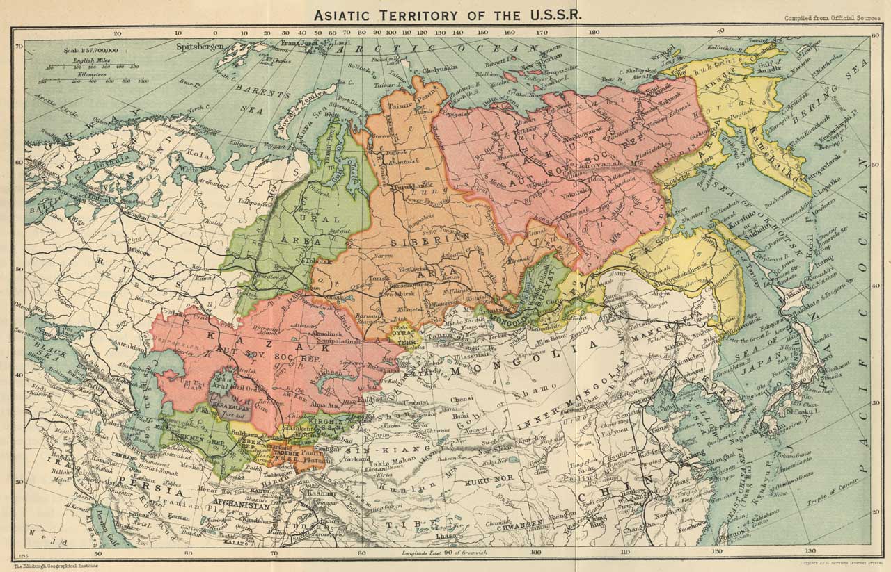
The Russian S.F.S.R. (Soviet Russia proper) contains nearly 70 per cent of the population of the Soviet Union and includes 92 per cent of its territory. The population under the census of December, 1926, was 100,858,000 and the area 19,757,953 square kilometers. Its territories stretch from the Latvian and Finnish borders and the White Russian and Ukrainian lines on the west, to the shores of the Pacific Ocean, and from the Arctic Ocean on the north to the shores of the Black and Caspian seas and the borders of Persia, Afghanistan, Mongolia and Manchuria on the south. It includes forty former provinces of European Russia, three provinces of the Northern Caucasus, the greater part of Siberia and the Far East. Its eleven autonomous republics and thirteen autonomous areas are representative of its principal minor national groups.
The White Russian S.S.R. [Byelorussia] was proclaimed January 1, 1919. [Note: All of these republics were given indepedence after the Soviet Revolution of November, 1917]
It had a population of 4,983,900 under the census of December, 1926, and an area of 126,792 square kilometers. It occupies six former counties of the Minsk province and parts of the old Smolensk, Vitebsk and Gomel provinces.
Under the Tsars White Russia was a pale of settlement of the persecuted Jewish population. It suffered greatly from periodical pogroms and from inter-racial struggles. Between 1914 and 1920 it was a field for military operations.
The racial composition is: White Russians 72.2 per cent, Russians proper 14.1 per cent, Jews 10.6 per cent, Poles 2 per cent, other nationalities 1.1 per cent.
The country is agricultural, the soil largely marshy and lacking in fertility. The lack of land was so great that the expropriation of the large holdings did not solve the problem. Some 250,000 acres have been added to the farm lands by drainage, and this will be increased to 5,400,000 acres during the next three years.
Principal industries: wood-working, linen, matches, leather, confections, oil pressing, glass, paper, foodstuffs. During the past few years the following industries have made large advances: machine building, knitting, tobacco, optical.
The Ukrainian S.S.R. is the most densely populated of the Constituent Republics with 19.7 per cent of the population of the Soviet Union in 2 per cent of the area. Under the census of December, 1926, its population was 29,020,300, with an area of 451,731 square kilometers. The Ukrainian S.S.R. was proclaimed in December, 1917, and formed in December, 1919. It borders on the Black Sea, with Poland and Rumania on its western and southwestern boundary respectively.
Of the total population 80 per cent are Ukrainians, 9.5 per cent Russians, 5.4 per cent Jews, 1.6 per cent Poles, and 3.5 per cent other nationalities: Greeks, Bulgarians, Rumanians, Gypsies, etc. There are also about 5,000,000 Ukrainians living in other portions of the Soviet Union. The city population of the Ukrainian S.S.R. includes 47.5 per cent Ukrainians, 25 per cent Russians, 22.7 per cent Jews. Three-fourths of the schools teach in the Ukrainian language. In respect to occupation 85.2 per cent of the population are farmers, 6 per cent workers, 4.2 per cent office employees, 4.6 per cent in various categories.
The Ukraine contains the famous black soil belt, the chief wheat-producing section of the Soviet Union. Sugar beets and oil seeds are important crops and livestock breeding is rapidly advancing.
In the Donetz Basin the Ukraine has a huge storage of coal, iron and other metals. Here are produced 75 per cent of the coal mined in the country, 70 per cent of the iron and a large proportion of the manganese, and there are heavily developed chemical and dye industries, salt mines, etc. Electric power development is making rapid advances and in the rural districts over 200,000 farms are supplied with current. On the Dnieper River the largest hydroelectric development in Europe is under construction, with an ultimate capacity of 500,000 horsepower.
The Transcaucasian Republic represents a union of three Soviet Socialist Republics: Azerbaijan, formed April, 1920; Armenia, formed December, 1920; and Georgia, formed February, 1921. In December, 1922, the First Transcaucasian Soviet Congress resulted in the federation of the three in a single Constituent Republic. The population under the census of December, 1926, was 5,850,700 and the area 184,492 square kilometers. Azerbaijan has a population of 2,313,200, capital Baku. Armenia has a population of 875,000, capital Erivan. Georgia has a population of 2,660,900, capital Tiflis. Azerbaijan contains one autonomous republic and Georgia two.
In addition to Armenians, Azerbaijan Turks, Georgians, Russians, Germans, Greeks and Persians, the conglomerate population includes many small nationalities such as Abkhasians, Adjarians, Aisors (Assyrians), Jews, Kurds, Ossetes, Talyshes, Tats, etc. Each of the nationalities maintains its own language, customs and habits. Some of them, like the Georgians and Armenians, have civilizations over a thousand years old, while others until recently have had no written language.
The Tsarist Government played one nationality against the other on the principle of "divide and rule."
Azerbaijan has at Baku the most important oil field in the world; Georgia in Chiaturi possesses the greatest known deposits of manganese. Other industries include copper mining, cotton ginning, silk spinning, leather factories, tanning plants, saw mills, dairies. Many new electrification projects are recently completed or in construction. Newly discovered natural riches include deposits of lead, zinc, silver, asbestos and pumice stone. Cotton is the principal crop.
These two republics in Central Asia were organized in 1924.
The Uzbek S.S.R. had a population of 5,270,200 under the census of December, 1926, and an area of 340,388 square kilometers. The Turkoman S.S.R. had a population of 1,030,500 and an area of 491,216 square kilometers. The area includes a new regrouping of Khiva and Bokhara.
At the beginning of the nineteenth century the Tsarist Government conquered this territory and suppressed all national independence and culture.
Cotton is the chief crop. Vineyards, fruit orchards and silk growing are also important. Irrigation is a necessity to agriculture and many large projects are under way. The five-year plan calls for an extension of the irrigated area to 3,400,000 dessiatins.
There is a marked development in cotton textile plants, ginning, coal mining, the oil industry, and the salt industry.
The eleven Autonomous Soviet Socialist Republics in the R.S.F.S.R. with their capitals and total populations are as follows:
| Republic | Population | Capital City |
| Bashkir | 2,695,000 | Ufa |
| Buryat-Mongol | 491,300 | Verkhnendinsk |
| Chuvash | 894,500 | Cheboksary |
| Crimean | 714,100 | Simferopol |
| Daghestan | 788,100 | Makhach-Kala |
| German-Volga | 571,900 | Pokrovsk |
| Karelian | 269,700 | Petrozavodsk |
| Kazak | 6,491,700 | KzyI Orda |
| Kirghiz | 993,100 | Frunze |
| Tartar | 2,594,000 | Kazan |
| Yakut | 278,800 | Yakutsk |
The thirteen Autonomous Areas in the R.S.F.S.R., with the administrative center and total population of each, follow:
| Autonomous Areas of the R.S.F.S.R. | ||
| Population | Capital City | |
| Adigheh | 114,200 | Krasnodar |
| Votyak | 956,300 | Izhevsk |
| Chechen(1) | 309,900 | Grozny |
| Karachai | 64,600 | Batalpashinsk |
| Circassian | 37,000 | Batalpashinsk |
| Jngush | 75,200 | Vladikavkaz |
| Kabardian-Balkar | 204,000 | Nalchik |
| Kalmuck | 141,600 | Ellista |
| Kara-Kalpak | 304,000 | Chimbai |
| Komi (Zyrian) | 207,800 | Ust-Sysolsk |
| Marl | 482,100 | Yoshkar-Ola |
| North-Ossetian | 152,400 | Vladikavkaz |
| Oirat | 99,900 | Ulala |
| The autonomous S.S.R., in the Ukrainian S.S.R. | ||
| Population | Capital City | |
| Moldavian | 572,000 | Baita |
| The three Autonomous Republics in the Transcaucasian Federation | ||
| Population | Capital City | |
| Nakhichevan (Azerbaijan) | 105,100 | Nakhichevan |
| Abkhasian (Georgia) | 200,500 | Snkhutn |
| Adjar (Georgia) | 131,300 | Batum |
| The two Autonomous Areas in the Transcaucasian Federation | ||
| Population | Capital City | |
| Mountain Karabakh (Azerbaijan) | 125,200 | Stepanakert |
| South Ossetian (Georgia) | 87,300 | Tskhinvaly |
| The Autonomous Republic in the Uzbek S.S.R. | ||
| Population | Capital City | |
| Tajik | 822,600 | Dushembe |
The divisions and subdivisions among the Constituent Republics of the U.S.S.R. correspond to racial or geographical demarkations. The autonomous republics and areas enjoy the greatest degree of self-government within their domestic spheres. Each has control over its own school system. Each of the several score of nationalities within the Soviet Union has complete freedom to use its own language in written or spoken form, including its use in the courts and schools, and to develop its own peculiar social usages. Compulsory Russification ended with the formation of the Soviet State.
Each constituent republic retains the right of free withdrawal from the Union.
Every citizen of the U.S.S.R. is completely free to conform to any religion or sect, or to none.
Ownership of all land and natural resources rests with the State in trust for all the people. Otherwise private property is recognized in the Civil Code.
The population of the U.S.S.R. is composed of 182 different nationalities, speaking 149 different languages or dialects. Under the census of December, 1926, the following thirty nationalities composed 97.6 per cent of the total population:
| Persons | Per cent of Total Population | |
| Russians | 77,760,100 | 52.9 |
| Ukrainians | 31,194,800 | 21.2 |
| White-Russians (West-Russia) | 4,739,900 | 3.2 |
| Kazaks (2) (Southwest Siberia and Central Asia) | 3,959,900 | 2.7 |
| Uzbeks (Central Asia) | 3,904,500 | 2.6 |
| Tartars (Middle Volga and Crimea) | 3,015,200 | 2.0 |
| Jews | 2,600,900 | 1.8 |
| Georgians (Transcaucasia) | 1,821,200 | 1.2 |
| Azerbaijan Turks (3) (Transcaucasia) | 1,706,600 | 1.2 |
| Armenians (Transcaucasia) | 1,567,500 | 1.1 |
| MordvinianS (Middle Volga) | 1,340,400 | 0.9 |
| Germans (Lower Volga) | 1,238,500 | 0.8 |
| Chuvashes (Middle Volga) | 1,117,400 | 0.7 |
| Ta] iks (Central Asia) | 978,200 | 0.7 |
| Poles (chiefly Ukraine and White Russia) | 782,300 | 0.5 |
| Kirghizes (Central Asia) | 768,70 0 | 0.5 |
| Turkomans (Central Asia) | 766,10 0 | 0.5 |
| Bashkirs (Ural) | 713,70 0 | 0.4 |
| Votyaks (Eastern Russia) | 504,20 0 | 0.3 |
| Man (Eastern Russia) | 428,20 0 | 0.3 |
| Chechens (Northern Caucasus) | 392,60 0 | 0.3 |
| Moldavians (Southwestern Ukraine) | 278,80 0 | 0.2 |
| Ossetes (Caucasus) | 272,20 0 | 0.2 |
| Karelians (Northwestern Russia) | 248,10 0 | 0.2 |
| Meshcheriaks (Eastern Russia) | 242,60 0 | 0.2 |
| Buryats (Eastern Siberia) | 237,50 0 | 0.2 |
| Komi (4) (Northeastern Russia) | 221,30 0 | 0.2 |
| Circassians (Northern Caucasus) | 219,00 0 | 0.2 |
| Yakuts (Eastern Siberia) | 214,80 0 | 0.2 |
| Greeks (South Russia and Ukraine) | 213,80 0 | 0.2 |
| Principal Cities and Population | ||
| Census of December, 1926 | Urban Census of 1923 | |
| Moscow | 2,025,947 | 1,511,045 |
| Leningrad | 1,614,008 | 1,067,328 |
| Kiev | 513,789 | 432,734 |
| Baku | 452,808 | 244,852 |
| Odessa | 420,888 | 316,762 |
| Kharkov | 417,186 | 310,264 |
| Tashkent | 323,613 | 263,871 |
| Rostov-on-Don | 308,284 | 236,421 |
| Tiflis | 292,973 | 233,958 |
The population of Moscow January 1, 1928, was 2,142,000, and that of Leningrad 1,676,800.
A number of cities have been renamed since the Revolution. The following are the principal changes:
| Former Name | Present Name |
| Ak-Mechet (Perovsk) | Kzyl-Orda |
| Alexandropol | Leninakan |
| Alexandroysk | Zaporozhye |
| Bakhnint | Artemovsk |
| Ekaterinbnrg | Sverdlovsk |
| Ekaterinodar | Krasnodar |
| Ekaterinoslav | Dniepropetrovsk |
| Elisavetgrad | Zinovievsk |
| Elisavetpol | Ganja |
| Gatchina | Trotsk |
| Novo-Nikolayevsk | Novosibirsk |
| Olviopol | Pervomaisk |
| Petrograd | Leningrad |
| Petrovsk-Port | Makhach-Kala |
| Pishpek | Frunze |
| Simbirsk | UIianovsk |
| Skobelev | Ferghana |
| Spassk | Byednodemyanoysk |
| Tsaritsyn | Stalingrad |
| Tsarskoye Selo | Detskoye Selo |
| Vyerny | Alma-Ata |
| Yamburg | Kingisepp |
| Ynzovka | Stalin |
Next: Government
(1) Some of the Autonomous Areas have no urban settlements, and in such cases their administrative centers are towns outside their own borders. This is the case with the Adigheh Area, the Chechen Area, the Circassian Area, the Kanchal Area, the Ingush Area and the North-Ossetian Area.
(2) Not to be confounded with the Cossacks.
(3) They are sometimes erroneously referred to as Tartars.
(4) They are also called "Zyrians" or "Sryenians".